
Carlson GIS
$1,350.00
Providing tools for data capture and linking, data labeling, import/export of SHP files, polygon topology creation and analysis, and more, Carlson GIS is an awesome GIS “Swiss Army Knife” for the surveyor or engineer.
See Available Discounts in Cart
Description
Put Your Designs on the Map
Carlson GIS can be purchased as a standalone module or as part of the Civil Suite which also includes Survey, Civil and Hydrology. It can run standalone with the included license of IntelliCAD or on top of a separately purchased license of full AutoCAD. All Carlson Software purchases will be delivered by email with your new serial number and download instructions within two business days.
Carlson GIS is comparable to other GIS mapping programs such as: DCA/Softdesk/Land Desktop, AutoCAD Map and Civil 3d.
STANDARD FEATURES
- GIS Database Settings
- Input-Edit GIS Data
- GIS Inspector
- GIS Inspector Settings
- GIS Query/Report
- Hatch GIS Polylines
- Mark GIS Polylines
- Label GIS Polyline: Closed Polyline Image
- Label GIS Polyline: Closed Polyline Data
- Label GIS Polyline: Open Polyline Data
- Links Manager
- Create Links
- Erase Links
GENERAL
- Built on AutoCAD – Runs in AutoCAD legacy versions as well as AutoCAD Map, Land Desktop and Civil3D and on IntelliCAD
- Project Setup – Flexible data storage methods
- Drawing Cleanup – Fix common drafting errors
- Drafting Enhancements – Handy tools for working in AutoCAD such as Join Nearest, Shrinkwrap Entities, Polyline Utilities, Drawing Inspector, Layer Inspector and Twist Screen
- Data Compatibility – Supports industry standard LandXML and scores of specific data conversions
GIS
- Runs with AutoCAD Map 3D – All Map tools are available when running with AutoCAD Map plus additional commands to use Map data such as Label Object Data Areas
- Data Capture – Extracts drawing text or block attributes into database
- Attach GIS Data to Entities – Input, edit, label, inspect and report with simple tools, including querying for parcels or entities that meet conditions
- Polygon Processor – Overlays layered polyline perimeters to create all the subareas
- Import/Export Esri – Conversions between Esri Shape data and coordinates and polylines
POINTS
- Import/Export – User-defined import and export of point data along with conversions with specific other formats
- Draw Points – Draw points with settings for symbols, layers and styles
- Point Groups – Point group manager to define sets of point by filters
- Coordinate File History – Tracks all changes to points with report and undo functions
- Fix Point Label Overlaps – Finds point label overlaps with rule options to fix automatically
- Point Tools – Utilities for modify point labels such as move with leader, twist and resize
COMPANION PROGRAMS
- Carlson SurvCE – Data collection for Windows CE and Pocket PC
- Carlson Field – Take Carlson and AutoCAD to the field for data collection and stakeout with total stations and GPS
- Carlson Takeoff – Construction Estimating for earthworks, subgrades, material quantities, strata quantities and trench networks
- Carlson Point Clouds – Process laser scan data to generate models, breaklines and points
- Carlson Natural Regrade – Design stable land surfaces that follow natural hydrologic and geomorphology principle
- Carlson Geology – Models drillholes and strata structures and attributes
New for 2027
Carlson 2027 brings new features and improvements to Carlson GIS. Here are the highlights:
General
- Support for IntelliCAD 14.1 (IntelliCAD 13.1 still provided for legacy compatibility) and full support for AutoCAD® 2027
- New Label Style Library with its own editor, plus a “Capture Style” button to copy a style from any existing text
- Native CAD table support for line, curve and other tables, including cell merging and font/cell sizing
- Drawing Cleanup can now find and remove dead data links, proxy objects and duplicate block references, and run saved settings on multiple drawings in a batch
- Improved Carlson-to-Civil 3D export of points, styles and templates
- New “Carlson Support Page” assistant: ask documentation questions in plain language from inside CAD
GIS
- “Validate Service Certificates” toggle for ArcGIS services on internal networks
- SQLite/SpatiaLite export writes NULL values and warns about missing primary keys
- Monument data added to point notes when importing ePlan or LandXML monuments
- “Use Attribute Layer” option for GEODB import and JPEG output restored in Convert MrSID Images
View the full Carlson 2027 Features and Improvements list (PDF)
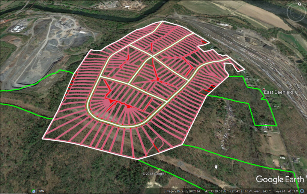
Screenshots
System Requirements
For Carlson’s CAD-based products
Carlson products installed on top of IntelliCAD or AutoCAD are subject to the same requirements as the CAD engine itself. Please follow the requirements for your CAD platform below and allow an additional 750 MB of hard-drive space for the Carlson application.
IntelliCAD (included)
Carlson 2027 runs on IntelliCAD 14.1, with IntelliCAD 13.1 also provided for legacy compatibility.
- Compatible with 64-bit Windows 8.1, 10 and 11
Hardware
Intel® i9, i7 or at least i5, AMD Ryzen 7/9, or comparable processors are recommended. Due to the variety of processors on the market, you can use cpubenchmark.net/cpu_list.php to compare them. While the overall processor score matters, single-thread performance is of the most interest.
- 64-bit Windows 8-11: 8 GB of RAM minimum, 16+ GB recommended
Graphics card compatible with OpenGL version 1.4 or higher:
- Discrete desktop-level graphics cards are recommended (not integrated graphics such as Intel HD)
- Nvidia is preferred due to more consistent driver support
- Discrete AMD cards are adequate, but AMD driver support has been spotty and users are often referred to the computer manufacturer for support
- High-end graphics cards are not required apart from demanding actions in Carlson Point Cloud. Gaming cards often provide better value than workstation cards, and more memory or a better CPU will generally help more than a high-end graphics card
Learn more about IntelliCAD.
Embedded AutoCAD® OEM engine
Carlson Survey OEM 2026 (AutoCAD 2026 embedded)
- 64-bit Microsoft® Windows 11 and 10
- Basic: 2.5-2.9 GHz processor with 8 logical cores; recommended: 3+ GHz processor
- 8 GB RAM (minimum), 16 GB (recommended)
- 10 GB free disk space for installation (SSD suggested)
- 1920 x 1080 monitor; resolutions up to 3840 x 2160 supported
- Display card with 2 GB GPU memory, 29 GB/s bandwidth and DirectX 11 compliance; 8 GB GPU memory with 106 GB/s bandwidth and DirectX 12 recommended
Carlson Takeoff R13 (AutoCAD 2022 embedded)
- 64-bit Microsoft® Windows 11 and 10
- Basic: 2.5-2.9 GHz processor; recommended: 3+ GHz processor
- 8 GB RAM (minimum), 16 GB (recommended)
- 10 GB free disk space for installation
- 1920 x 1080 monitor; resolutions up to 3840 x 2160 supported
- Display card with 1 GB GPU memory, 29 GB/s bandwidth and DirectX 11 compliance; 4 GB GPU memory with 106 GB/s bandwidth and DirectX 12 recommended
- Install from download
AutoCAD® purchased separately
Carlson 2027 is compatible with AutoCAD® 2027. Please see the AutoCAD system requirements for specifications, which are subject to change without advance notice. See above for the hard-disk space needed for the Carlson application.
PhotoCapture Standalone
| Hardware | Minimum | Recommended |
| CPU | Intel i9 / AMD Ryzen 7 | Intel i9 14th gen / AMD Ryzen 9 |
| CPU cores | 8 / 8 | 24 / 16 |
| CPU threads | 16 / 16 | 32 / 32 |
| RAM | 32 GB | 64 GB or more |
| NVMe SSD | 1 TB free | 2 TB or more free |
| Graphics card | Nvidia GeForce* | Nvidia GeForce* |
* PhotoCapture does not use the GPU, but Nvidia GeForce series cards are recommended for other Carlson Software products.
Free Support
Carlson Software Works For You
A customer’s relationship with Carlson Software goes beyond simply purchasing our software – with Regional Managers throughout the country, free technical support for life, and training options for any budget – we’ve got you covered!
Carlson Software Direct Technical Support
- Hours: Monday – Friday, 8:00 AM – 6:00 PM (EST)
- E-mail: moc.wsnoslrac@troppus
- Problems/Suggestions: Send in a report
- Telephone: 606-564-5028
- Fax: 606-564-6422